
The Atlantic Coast of the United States, 1886. High-resolution image (click three times for full size).
The Atlantic Coast of the United States, 1886. High-resolution image (click three times for full size).
Engraved by Charles E. Birch and John A. Waddey, and drafted by Leon Dessez.
Courtesy of Boston Public Library. Click here to see source.
 This work is licensed under a Creative Commons Public Domain Mark 1.0 License.
In 1880, the United States recorded a historic peak in cod landings— about 133,000 metric tons —a figure that would never be reached again. This milestone in marine resource extraction holds particular significance in the history of North Atlantic fisheries, as it signaled the shift toward industrialized and mechanized operations, with larger vessels, more efficient fishing gear, and a growing influence of market demands on the rhythms of coastal life. However, it also foreshadowed a period of severe ecological depletion.
New England formed the core of US fish landings at the time, accounting for almost 45 percent of the total value of US general fisheries. The region’s proximity to highly productive fishing grounds, like Georges Bank, played a central role in this dominance. These vast underwater plateaus were rich not only in Atlantic cod (Gadus morhua) but also in a variety of pelagic and demersal species, sustaining a regional economy deeply connected to the sea.

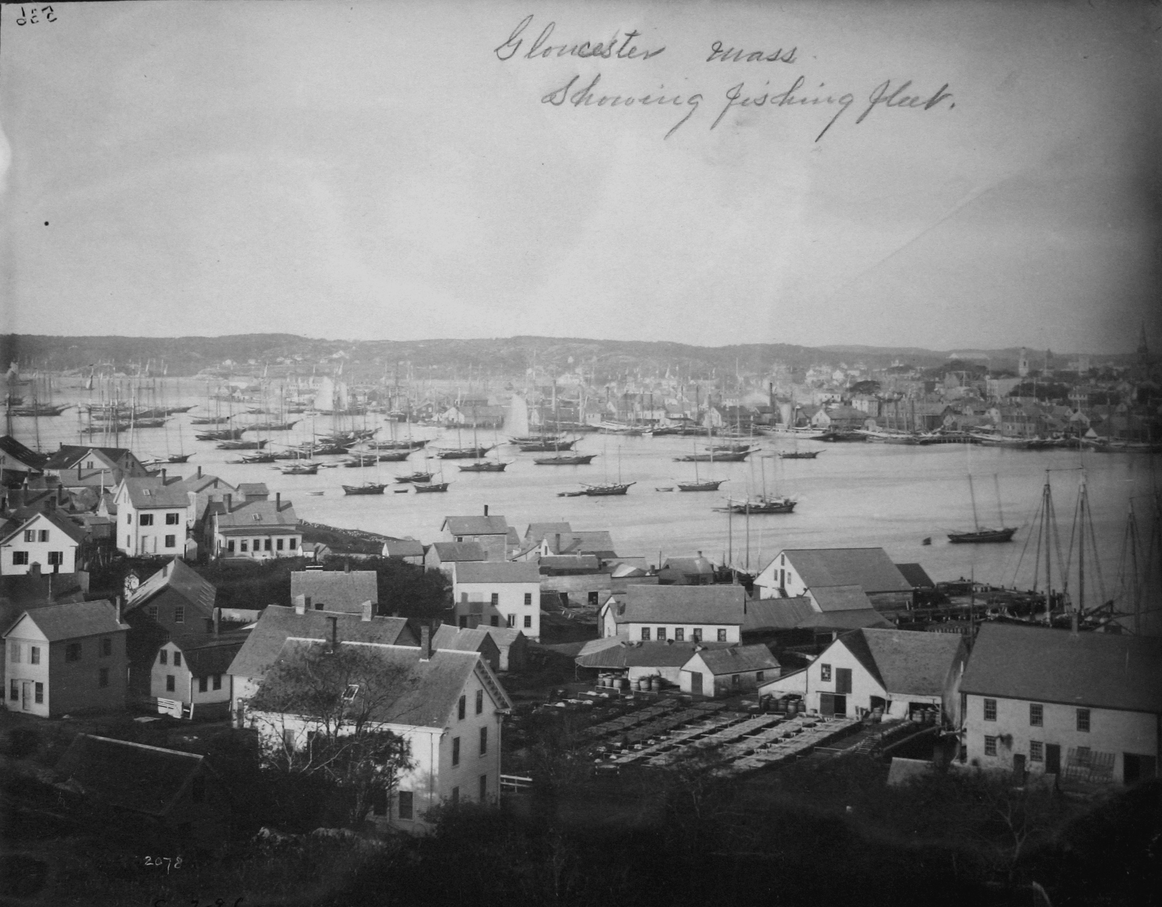
Gloucester’s fishing fleet, c. 1905.
Gloucester’s fishing fleet, c. 1905.
Courtesy of NOAA Central Library. Click here to view LOC source.
This work is licensed under a Creative Commons Public Domain Mark 1.0 License.
Among the many coastal towns involved in the fishing industry, Gloucester, Massachusetts, stood out as a key hub of activity. With a long-standing maritime tradition and a well-situated harbor, it became a central node in the American fishing network. Records from the International Commission for the Northwest Atlantic (ICNAF) covering the period between 1895 and 1925, alongside data from the US Commission of Fish and Fisheries, show that Gloucester accounted for around 29 percent of total US groundfish landings from the Northwest Atlantic. Even more impressively, the town contributed an average of five percent of the total groundfish landings recorded across multiple fishing nations, including Canada, France, Portugal, and Denmark. These are striking figures for a town that, during this period, had an average population of approximately 25,000 residents.
Flake yard, Gloucester, c. 1905.
Flake yard, Gloucester, c. 1905.
Unknown photographer, n.d.
Courtesy of NOAA Central Library. National Archive, College Park, MD.
This work is licensed under a Creative Commons Public Domain Mark 1.0 License.
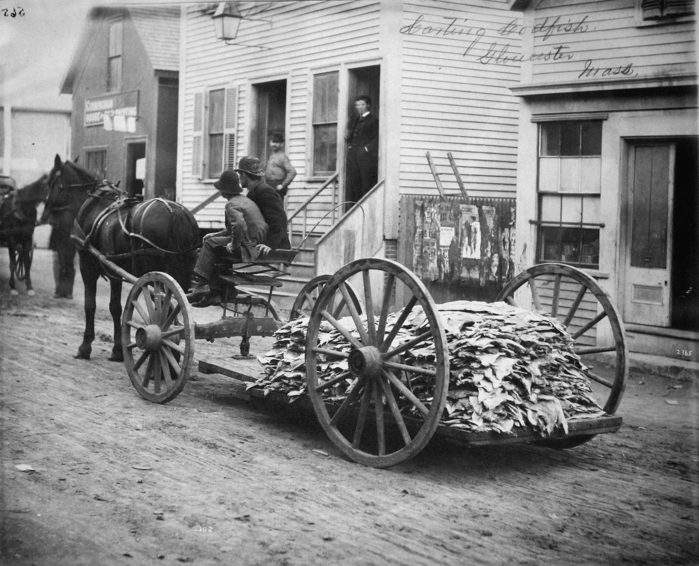
Fishing was not only central to Gloucester’s economy but also deeply embedded in its built environment. The harbor was densely packed with schooners and small fishing boats, while the shoreline was lined with wooden wharves, saltfish warehouses, cooperages, and extensive drying racks. On hot days, the smell of drying cod permeated the entire town, a pungent reminder of the fishing economy’s importance in everyday life.

Carting codfish, Gloucester, c. 1890.
Carting codfish, Gloucester, c. 1890.
Courtesy of NOAA Central Library. National Archive, College Park, MD.
This work is licensed under a Creative Commons Public Domain Mark 1.0 License.
While cod and other groundfish remained dominant, pelagic species such as mackerel, herring, and menhaden were equally vital, allowing the industry to adapt to fluctuating ecological conditions, seasonal availability, and shifting market demands. The town’s location further enhanced this adaptability, offering quick access to both small inshore grounds—particularly abundant in species other than cod—and major offshore banks like Georges Bank, roughly 150 nautical miles away. Some voyages, however, extended much farther, reaching the Grand Banks of Newfoundland (around 850 nautical miles) or the icy waters off Labrador (more than 1,600 nautical miles away). This broad maritime range secured a stable supply of resources, enabling fleets to offset the decline of specific stocks by shifting between different fishing grounds.
The ongoing research developed within the Fishing Architecture project seeks to map the territorial and environmental footprint of these fisheries while contributing to a more integrated understanding of the environmental history of the North Atlantic. Historical records from the US Commission of Fish and Fisheries have been digitized and organized into a dataset that includes fish landings, targeted species, volumes, fishing grounds, and prices. When combined with historical nautical maps and processed through Geographic Information Systems (GIS), these sources enable a layered reconstruction of fishing activity across time and space.
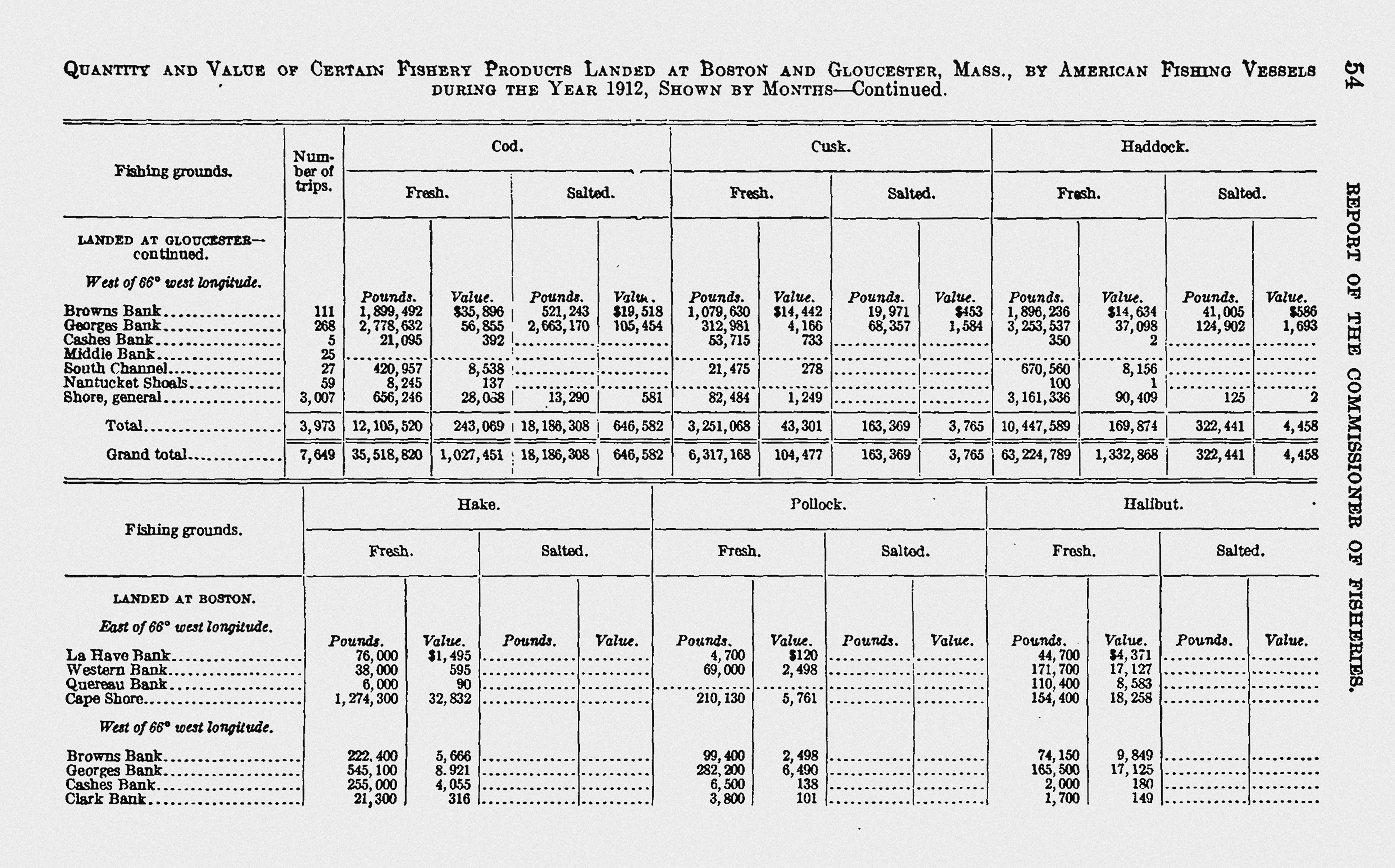
Fishery products landed at Boston and Gloucester, Report of the Commissioner of Fisheries, 1912.
Fishery products landed at Boston and Gloucester, Report of the Commissioner of Fisheries, 1912.
Courtesy of NOAA Central Library. Click here to view source
This work is licensed under a Creative Commons Public Domain Mark 1.0 License.
The integration of historical data with geospatial tools makes it possible to track seasonal fluctuations, long-term shifts in fishing pressure, and the gradual extension of fishing zones. These patterns help us understand how marine resources shaped not only coastal economies but also urban settlements and their architecture. Most importantly, they allow us to visualize the deep, and often difficult to perceive, interdependence between human societies and marine ecosystems.
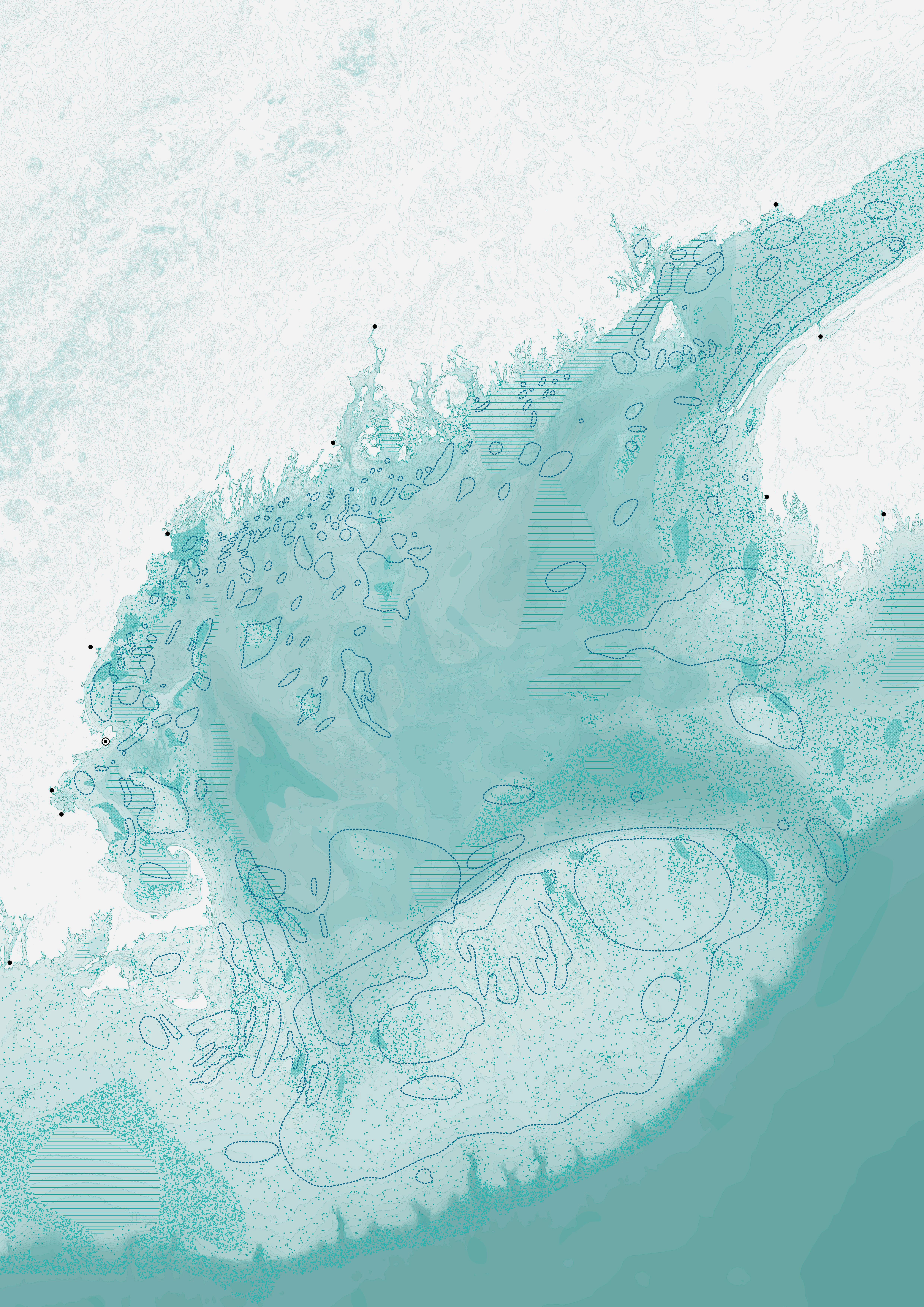
Fishing grounds off the Gulf of Maine, 2026. Fishing areas drawn from Walter Rich 1998, over seafloor sediments characteristics by Lawrence J. Poppe et al., 1989. Black dots indicate major fishing ports; the circled black dot represents Gloucester. High-resolution image (click three times for full size).
Fishing grounds off the Gulf of Maine, 2026. Fishing areas drawn from Walter Rich 1998, over seafloor sediments characteristics by Lawrence J. Poppe et al., 1989. Black dots indicate major fishing ports; the circled black dot represents Gloucester. High-resolution image (click three times for full size).
Graphic by Rafael Sousa Santos, 2026.
 This work is licensed under a Creative Commons Attribution 4.0 International License.
While the history of fisheries in New England has been extensively documented, the approach taken in this study introduces a new dimension: the capacity to visualize and quantify relationships that were previously hidden. These materials show that the sea, far from being an unbounded wilderness, was increasingly territorialized. Regions were named and categorized not only by their seafloor topography and sediment types, but also by the presence of particular fish species at specific times of the year, serving as repositories of ecological knowledge.
The combined data from landing records and navigational charts provide a detailed picture of how Gloucester’s fisherfolk interacted with these maritime territories. We can track how many trips were made to specific grounds, how far vessels traveled, and how these mobility patterns evolved over time. Such information offers valuable insight into decision-making processes, labor rhythms, and responses to environmental and economic pressures. Moreover, by cross-referencing species, catch volumes, and spatial coordinates, we can begin to reconstruct the footprint of Gloucester’s fisheries—paving the way for informed interpretations of marine environmental history and contributing to ongoing debates about sustainability, depletion, and adaptation in marine resource use.
Although this analysis remains descriptive in its current stage, it lays the groundwork for future research. Ongoing statistical and spatial analysis will soon yield more detailed results on the long-term evolution of fishing patterns, the impact of industrialization, and the territorial transformations that ensued both on land and at sea. Ultimately, this research will help us understand how humans have shaped, and been shaped by, their marine environment.
Acknowledgments
Funded by the European Union (ERC, Fish-A, 101044244). Views and opinions expressed are however those of the authors only and do not necessarily reflect those of the European Union or the European Research Council. Neither the European Union nor the granting authority can be held responsible for them.
How to cite
Sousa Santos, Rafael. “Territories of the Sea: Outlining a Spatial History of Gloucester’s Fisheries.” Environment & Society Portal, Arcadia (Spring 2026), no. 10. Rachel Carson Center for Environment and Society. https://www.environmentandsociety.org/node/10151
ISSN 2199-3408
Environment & Society Portal, Arcadia
This work is licensed under a Creative Commons Attribution 4.0 International License.
2025 Rafael Sousa Santos
This refers only to the text and does not include any image rights.
Please click on an image to view its individual rights status.
- Lear, W. H. “History of Fisheries in the Northwest Atlantic: The 500‐year Perspective.” Journal of Northwest Atlantic Fishery Science, 23 (1998): 41–73. (Available here.)
- Bolster, W. Jeffrey. The Mortal Sea: Fishing the Atlantic in the Age of Sail. Harvard University Press, 2012.
- “Statistics of the Fisheries of the United States in 1880.” Bulletin of the United States Fish Commission 3, no. 1 (1883). Available at https://spo.nmfs.noaa.gov/content/statistics-fisheries-united-states-1880
- Tavares, Andre. Architecture Follows Fish: An Amphibious History of the North Atlantic. MIT Press, 2024.


