The city of Chennai, capital of the state of Tamil Nadu, is the fourth largest and one of the fastest growing metropolises of India. Located at 13°N, 80°E, the city is on the east coast of India and faces the Bay of Bengal making it naturally prone to tropical cyclones. The city is also water-scarce and has the lowest per capita availability of water among the four metro cities of India.
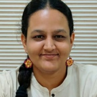
The unique feature of Chennai’s rainfall is that the major share is received during the northeast monsoon in the months of October to December. In November and December of 2015, Chennai received unprecedented levels of rainfall leading to the overflow of the arterial Adyar river, which in turn led to floods in the city. Multiple low-lying areas in the city were inundated for days together; massive rescue and evacuation efforts had to be undertaken in areas where houses were getting submerged.

Rescue efforts being undertaken via boats.
Rescue efforts being undertaken via boats.
Photograph by rsriramtce.
Accessed via Wikimedia Commons on 22 June 2021. Click here to view source.
 This work is licensed under a Creative Commons Attribution 4.0 International License.
Airborne evacuation and relief provision were rendered impossible due to the flooding of the city’s sole airport whose secondary runway had incidentally been constructed over what was once a part of the Adyar river. The flood carried with it an economic cost and the global insurance company Munich Re estimated the loss in and around Chennai to be at the tune of USD 3.5 billion, making it among the most costly global events of the year, second only to the Nepal earthquake.
The city is no stranger to flooding. In 2007, a Drescher et al. study on risk perception consisting of analysis of flood risk exposure and the development of flood risk maps showed that flooding is a regular occurrence. The study documented a total of 26 floods from 1943 to 2006 and noted a sharp increase in the number of flooding events from the 1970s. Before this could be categorized as a direct correlation of climate change, the study also highlighted, based on the meteorological data from 1813, that there has been no increase in the rate of rainfall received annually over the years. Floods of 1996 and 2005 had been caused by strong single rainfall events exacerbated by manmade pressures.
What is interesting to note is that in the month of November in 2015, the event in large part was referred to as “Chennai Rains,” including on social media. An article on 18 November in the newspaper Mint for instance opened by reporting that Chennai “woke up to a clear sky on 17 November after a week of incessant downpour that threw life out of gear” and called the city “water-logged.” A cursory scan of media coverage of 2015 now shows that it is widely cited as the “Chennai floods.” How, when, and why did “rains” become “floods”?
First, despite the state’s impressive rescue efforts, the events of 2015 reiterated the lack of understanding of the city’s natural drainage systems. The state’s decision to drain the excess water from one of the city’s three main reservoirs added to the already-heightened volume of the Adyar river which is part of its natural flow pattern, leading to sudden flooding.
Second, the state’s decision led to flooding in parts of the city that had earlier been immune to water-logging. These new areas which flooded were the affluent neighborhoods of Chennai, bringing the dangers of haphazard urban planning to everyone’s doorsteps as a reality to immediately confront.
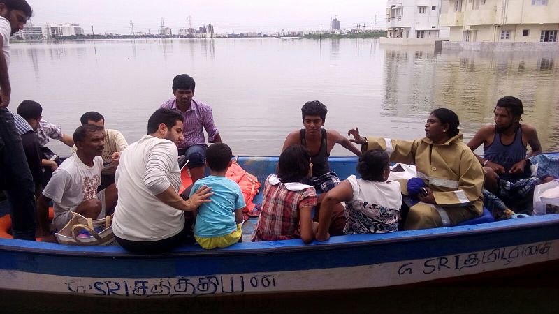
Third, and perhaps most important, postmortem studies on the floods illustrated how rapid and unchecked urbanization had taken its toll on the city’s wetlands and made the city vulnerable. A study by Care Earth Trust showed the increase in built-up area over the decades corresponding to the decrease in the area of wetlands and waterbodies. In recent times, there is a tendency to externalize the cause of a natural disaster to climate change, making it difficult to visualize and identify immediate causes and solutions. In this case, the emphasis on how a disaster that deeply affected the psyche of the city could have been avoided through better urban planning and management has enabled residents of the city to understand this as something within control.
After the 2015 floods, the city has witnessed a mobilization of government, civil society, and academia towards concepts such as flood risks and urban resilience. Discussions on hydrology as a key metric for urban planning and on the need for livelihood safety nets for the urban poor are entering the mainstream planning agenda. In contrast to earlier waterlogging events, post-2015 there is an increased emphasis on the restoration of the city’s wetlands and natural hydrological courses. While this has taken root in theory in urban planning, it needs to translate into practice on a larger scale.
How to cite
Vencatesan, Anjana. “From Rains to Floods: A Case of Chennai in 2015.” Environment & Society Portal, Arcadia (Summer 2021), no. 23. Rachel Carson Center for Environment and Society. doi:10.5282/rcc/9323.
ISSN 2199-3408
Environment & Society Portal, Arcadia
This work is licensed under a Creative Commons Attribution 4.0 International License.
2021 Anjana Vencatesan
This refers only to the text and does not include any image rights.
Please click on the images to view their individual rights status.
- Anand, Jay, and Uma Ramachandran. Role of Various Sectors in Demonstrating Resilience During Chennai Flood 2015. New Delhi: TARU Leading Edge, 2016. (Link)
- Bhaskar, Avantika, G. Babu Rao, and Jayshree Vencatesan. “Characterization and Management Concerns of Water Resources around Pallikaranai Marsh, South Chennai.” In Reconsidering the Impact of Climate Change on Global Water Supply, Use, and Management, edited by Prakash Rao and Yogesh Patil, 102–121. Hershey, PA: IGI Global, 2017. doi:10.4018/978-1-5225-1046-8.ch007
- Disaster in Chennai Caused by Torrential Rainfall and Consequent Flooding. (2016), Report no. 198, Department related Parliamentary Standing Committee on Home Affairs, Rajya Sabha, Parliament of India.
- Drescher, Axel, Rüdiger Glaser, Constanze Pfeiffer, Jayshree Vencatesan, Elke Schliermann-Kraus, Stephanie Glaser, Marco Lechner, and Paul Dostal. (2012). “Risk Assessment of Extreme Precipitation in the Coastal Areas of Chennai as an Element of Catastrophe Prevention.” 8. Forum DKKV/CEDIM: Disaster Reduction in Climate Change, Karlsruhe University, October 2007.
- Pfeiffer, Constanze, Stephanie Glaser, Jayshree Vencatesan, Elke Schliermann-Kraus, Axel Drescher, and Rüdiger Glaser. “Facilitating Participatory Multilevel Decision-Making by Using Interactive Mental Maps.” Geospatial Health 3, no. 1 (2008): 103–112. doi:10.4081/gh.2008.236
- Warrier, S. Gopikrishna. “Encroached wetlands, cut trees increase climate risks in Chennai.” India Climate Dialogue, 23 October 2017. (Link)


