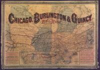
Map: CB&Q map of Chicago, 1880
This 1880 map centered on Chicago displays the early CB&Q railroad route.
In the special section “Imagining Anew: Challenges of Representing the Anthropocene,” Wolfgang Struck’s essay examines the renewed attraction to the medium of the atlas in light of representational challenges raised by the model of the Anthropocene.
In episode 46 of Nature’s Past, a podcast on Canadian environmental history, Sean Kheraj speaks with the editors of Historical GIS Research in Canada, Jennifer Bonnell and Marcel Fortin, as well as a few contributors.
The Eldgjá eruption in Iceland in the late 930s CE seems to have had tremendous repercussions. Only a few historical documents were written during the time in question.
The authors explore the implementation of Traditional Ecological Knowledge (TEK) and Indigenous knowledge (IK) in mapping efforts, taking cues from previous spatio-temporal visualization work in the Geographic(al) Information System(s)/Science(s) GIS community, and from temporal depictions extant in existing cultural traditions.
Ansgar Schanbacher charts the history of urban development in Göttingen focusing on the degree to which previously green and fertile agricultural areas have been sealed due to the demands of industrial development.
Ansgar Schanbacher ripercorre gli sviluppi urbani passati e recenti di Gottinga, soffermandosi sull’accelerazione del consumo di suolo che ha progressivamente visto sparire numerose aree agricole. Il futuro, però, potrebbe riservare sorprese.
Kenneth Olwig on landscape. This is an entry in the KTH EHL VideoDictionary.
In this episode from the New Books Network podcast, Candace Fujikane is interviewed on her book, Mapping Abundance for a Planetary Future: Kanaka Maoli and Critical Settler Cartographies in Hawai’i.
This study reviews the main changes of the vegetation and fauna in northern Portugal during the Holocene, using literature from palaeoecology, archaeology, history, writings from travellers and naturalists, maps of agriculture and forestry and expert consultation.