
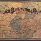
1880 map of the Chicago, Burlington & Quincy Railroad.
1880 map of the Chicago, Burlington & Quincy Railroad.
Courtesy of Newberry Library.
Used with permission of the Newberry Library. With questions about reuse of this image, contact the Newberry Library.
The copyright holder reserves, or holds for their own use, all the rights provided by copyright law, such as distribution, performance, and creation of derivative works.
This image appears in: Olmanson, Eric D. “Promotion and Transformation of Landscapes along the CB&Q Railroad.” Environment & Society Portal, Virtual Exhibitions 2011, no. 1. Rachel Carson Center for Environment and Society. http://www.environmentandsociety.org/node/2715.
The 1880 map shows Chicago as a crossroads of transportation, with rail lines radiating out in all directions except where Lake Michigan represents its shipping lanes. The map depicts the early heart of the CB&Q, from northern Illinois through southern Iowa and northern Missouri, with Chicago at the center of the map.
—Eric D. Olmanson
Read more here.