Introduction

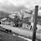
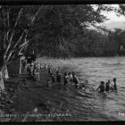
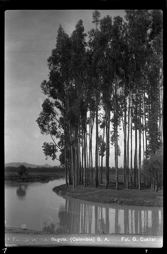
Paisaje del Río Bogotá (Colombia) S.A. The landscape of the Bogotá River. One of the riverbanks is planted entirely with eucalyptus. (Photograph by Gumersindo Cuéllar Jiménez. © Biblioteca Luis Ángel Arango.)
Paisaje del Río Bogotá (Colombia) S.A. The landscape of the Bogotá River. One of the riverbanks is planted entirely with eucalyptus. (Photograph by Gumersindo Cuéllar Jiménez. © Biblioteca Luis Ángel Arango.)
© Biblioteca Luis Ángel Arango. Banco de la República de Colombia. Courtesy of Mario Cuéllar Bobadilla. Collection Gumersindo Cuéllar Jiménez, Reference FT1676 brblaa791800-3.
The copyright holder reserves, or holds for their own use, all the rights provided by copyright law, such as distribution, performance, and creation of derivative works.
A green chain of mountains on its eastern flank, a western savanna, and a streaming system of rivers and wetlands form the cornerstone of the ecological structure of Bogotá, with water as its vehicle. This is not a mere geographical setting, but form the very ecological core of the history of Bogotá. An environmental history of this city must begin with the acknowledgement that most of its society’s earlier experience is significantly linked to the web of relations created by the shifting connections within this ecological structure. Taking this into account, this virtual exhibition focuses on the relationships between water and society at a time when Bogotá became a modern city in terms of population growth, industrialization, development of urban infrastructure, dissemination of bourgeois cultural habits, and the emergence of a more strict biopolitical control, especially on marginal sectors.
The visually powerful Eastern Mountains (Cerros Orientales) are arguably the most striking feature of Bogotá. They form such a prominent boundary that most city maps are oriented to the east rather than to the north, presenting the green belt as a boundary within which the city is staged. These slopes belong geologically to the Eastern Cordillera and are ecologically defined as the Andean zone of cloud forests and páramos—that is, the unique and protected Andean moorland above the tree line approximately 3,300 meters above sea level. The páramos play a special role in water regulation because of their extraordinary vegetation cover and soil moisture, so much so that they have been labeled a “water factory.”
On the slopes of the Eastern Mountains lies the high plateau of the Bogotá Savanna (Sabana de Bogotá), named for its flat topography and grass cover. Both the savanna and the surrounding mountains were occupied in pre-Hispanic times by the Muisca indigenous people. This group settled upon the site well before the Spaniards officially founded Santafé de Bogotá in 1538, 2,664 meters above sea level and close enough to the indigenous site to enjoy the benefit of food supplies and an existing workforce.

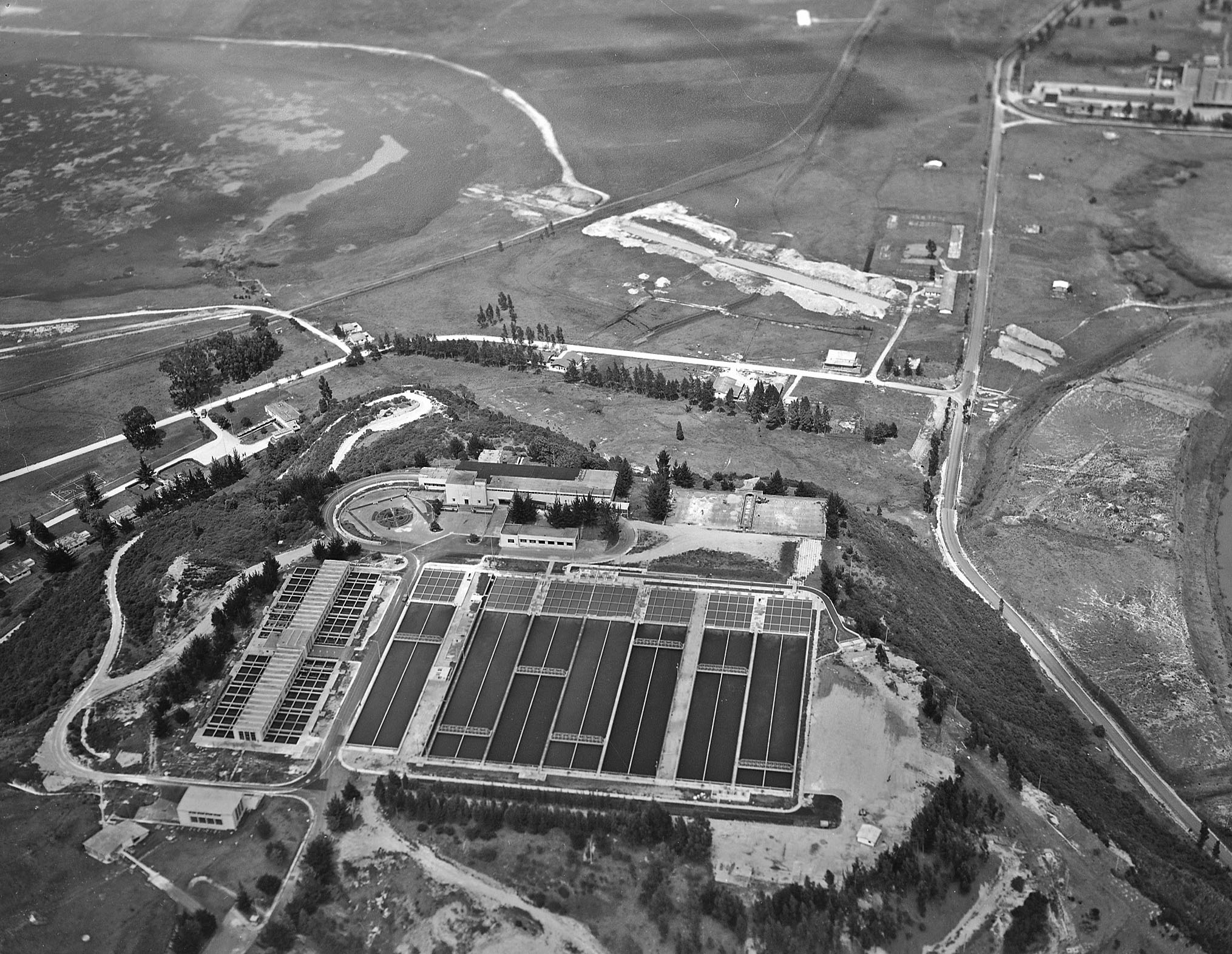
Saúl Ordúz, Tibitoc Treatment Plant, 1974
Saúl Ordúz, Tibitoc Treatment Plant, 1974
© 1974 Saúl Ordúz. Courtesy of Museo de Bogotá, Instituto Distrital de Patrimonio Cultural. Collection Luis Alberto Acuña, Reference MdB03719
The copyright holder reserves, or holds for their own use, all the rights provided by copyright law, such as distribution, performance, and creation of derivative works.
Every stream that has been important to the city has been a tributary of the Bogotá River. The river crosses the savanna from north to south, eventually reaching the Magdalena River, the main fluvial artery in Colombian geography. San Francisco and San Agustín—the main streams of the city in the colonial period and into the nineteenth century—spring up from the eastern mountains of Monserrate and Guadalupe, joining together in a single riverbed that flows into the larger Fucha River, a tributary of the Bogotá River. The Arzobispo River, also important during this period, has its source in the Verjón Lake in the Cruz Verde Páramo, from where it runs first northwards then westwards, descending from the mountains through the National Park (Parque Nacional Enrique Olaya Herrera). Within the city the river continues to the northwest, sharply changing its direction to the north where it becomes the Salitre. It turns again to the northwest as the Juan Amarillo River, finally flowing into the Bogotá River after passing through the Salitre Wastewater Treatment Plant.
The Salitre was in fact one of the rivers supporting the twentieth-century development of the Colombian capital city, along with the Tunjuelo and San Cristóbal-Fucha Rivers. The Tunjuelo River flows from the Sumapaz Páramo, providing water to the Chisacá and La Regadera Reservoirs, and then crossing the southern part of the city from east to west to reach its mouth at the Bogotá River. The San Cristóbal River, whose source is located in the Cruz Verde Páramo, becomes the Fucha River as it enters the city, running parallel to the Tunjuelo before emptying into the Bogotá River.

Luis Alberto Acuña, Quinta de Bolívar, 1920
Luis Alberto Acuña, Quinta de Bolívar, 1920
© 1920 Luis Alberto Acuña. Courtesy of Museo de Bogotá, Instituto Distrital de Patrimonio Cultural.
The copyright holder reserves, or holds for their own use, all the rights provided by copyright law, such as distribution, performance, and creation of derivative works.

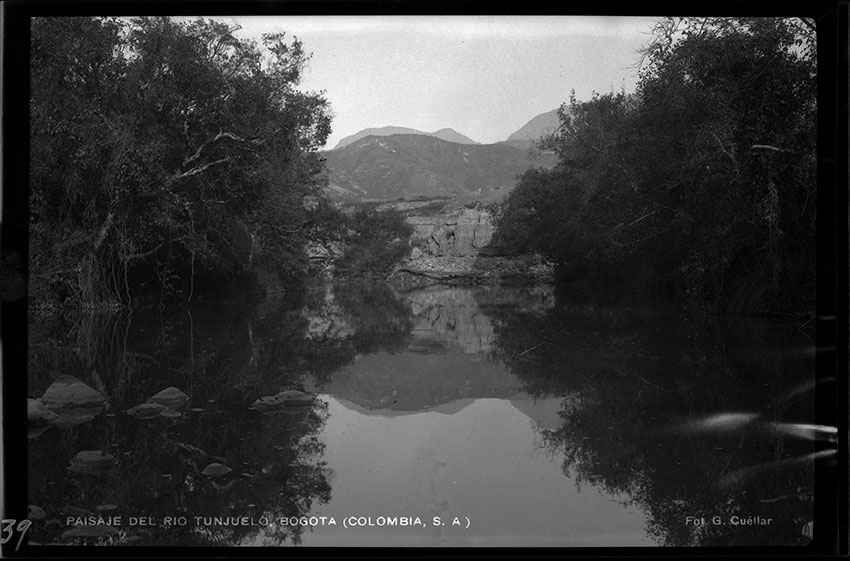
Gumersindo Cuéllar Jiménez, Paisaje del Río Tunjuelo. Bogotá (Colombia, S.A.)
Gumersindo Cuéllar Jiménez, Paisaje del Río Tunjuelo. Bogotá (Colombia, S.A.)
The landscape of the Tunjuelo River, with which the population of Bogotá established a varied relationship throughout the twentieth century. Close to its source in the Sumapaz Páramo, the river filled the La Regadera and Chisacá Reservoirs, contributing to urban water supplies. But by running through the city, the river’s function as a water source changed into negatively-perceived roles as an obstacle to urbanization, a center for pollution, and a hazardous flood threat.
All rights reserved. Biblioteca Luis Ángel Arango. Banco de la República de Colombia. Courtesy of Mario Cuéllar Bobadilla.
The copyright holder reserves, or holds for their own use, all the rights provided by copyright law, such as distribution, performance, and creation of derivative works.
On their way down from the páramos and mountains, this dense group of rivers feeds the wetland complexes associated with the Bogotá River basin and floodplain. The ecological and economic importance of the wetlands is well known, and this importance justifies environmental conservation measures: the wetlands act as sponges by retaining water during the rainy season, and play a part in regulating floods and water availability. They also serve as important actors by reducing water pollution, as the plants and vegetation in the swampy wetlands digest organic material while retaining sediments and metals.
By the end of the nineteenth century, the governing elite, commercial bourgeoisie, and politically influential forces of sanitary reformers—including engineers and physicians—envisioned a need for modernity in the stagnant Bogotá, motivating strong urban transformations that fulfilled these expectations. In their eyes, to be a modern city meant a series of measures to discipline both urban society and the urban environment. River flows had to be diverted, bacterial proliferation controlled, personal hygiene conditioned, and waste disposal managed. As elsewhere in the Western world, urban modernization was perceived as a tighter means of human control of, or even separation from, nature, through science, medicine, and technology.

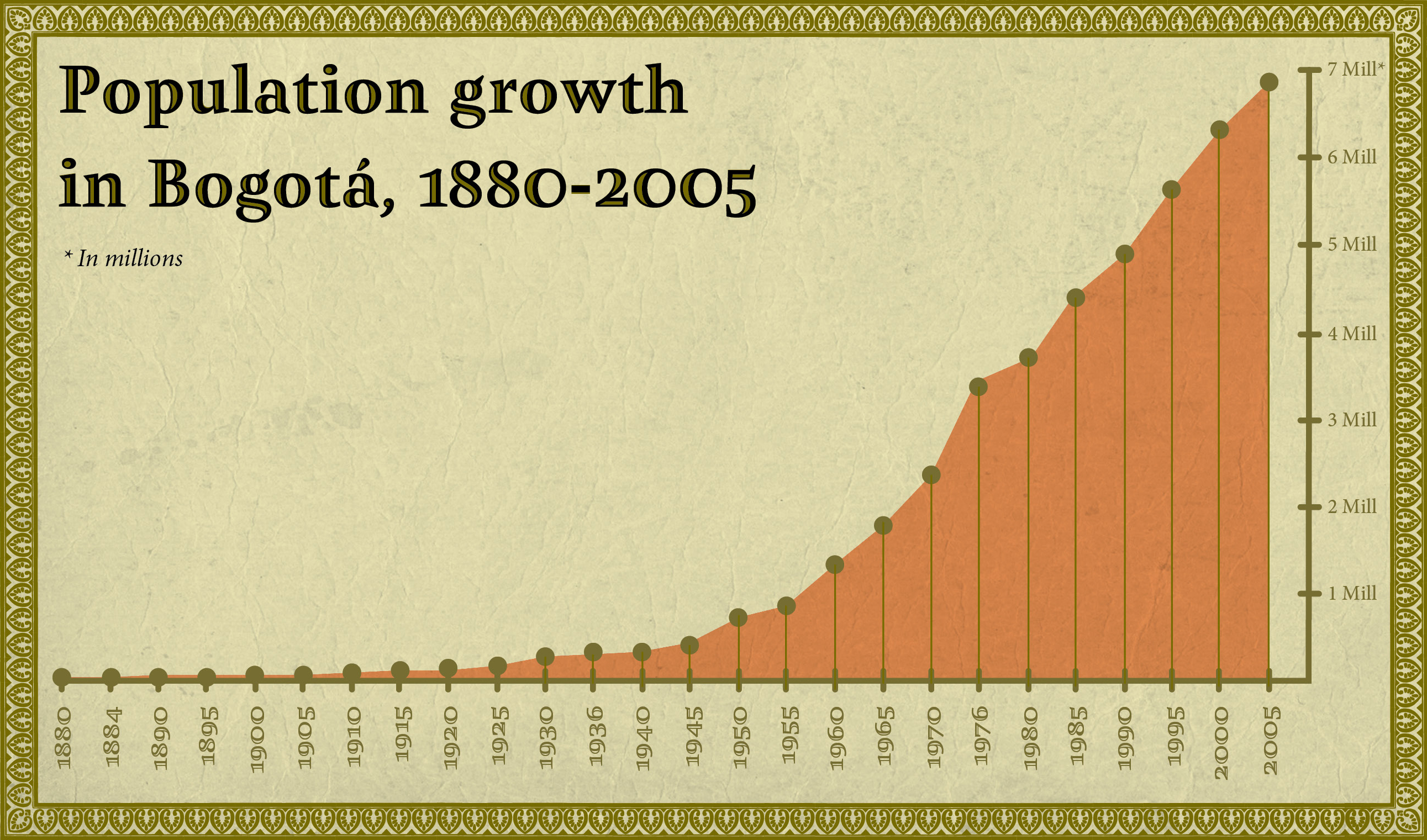
Population growth in Bogotá, 1880–2005
Population growth in Bogotá, 1880–2005
It is clear that the urban population radically increased from the mid-twentieth century as a result of waves of migration from the countryside to the cities, caused by the rural political violence that has marked the history of Colombia.
Departamento Administrativo Nacional de Estadística, ed. XV Censo Nacional de Población y IV de Vivienda. Colombia. Bogotá: Departamento Administrativo Nacional de Estadística, 1986, 32.
Departamento Administrativo Nacional de Estadística, ed. Censo General 2005. Nivel Nacional. Bogotá: Departamento Administrativo Nacional de Estadística, 2008, 35.
Departamento Administrativo Nacional de Estadística, ed. “Evolución de la Población 1985–2005, Bogotá D.C. Según Proceso de Conciliación Censal y Proyecciones de Población.” Accessed 7 February 2014.
Germán Mejía Pavony. Los Años del Cambio: Historia Urbana de Bogotá, 1820–1910. Bogotá: Centro Editorial Javeriano CEJA, 1999, 230.
Alfonso Pérez Preciado. “La Expansión Urbana de Bogotá: Mitos y Realidades.” In Territorio y Sociedad: El Caso del Plan de Ordenamiento Territorial de la Ciudad de Bogotá, edited by Gerardo Ardila, 94-95. Bogotá: Ministerio del Medio Ambiente, Universidad Nacional de Colombia, 2003.
María Clara Torres. El Alcantarillado de Bogotá 1886–1938: Institucionalización de un Problema Ambiental. Tesis de Maestría en Medio Ambiente y Desarrollo, anexo 3, Universidad Nacional de Colombia, 2010.
Julián Vargas Lesmes, and Fabio Zambrano. “Santa Fe y Bogotá: Evolución Histórica y Servicios Públicos (1600–1957).” In Bogotá 450 Años. Retos y Realidades. Bogotá: Foro Nacional por Colombia—Instituto Francés de Estudios Andinos, 1988, 15, 19, 22, 40.
Designed by Mónica Páez Pérez and María José Castillo Ortega. Tangrama, 2014.
 This work is licensed under a Creative Commons Attribution-NonCommercial-ShareAlike 3.0 Unported License.
Population dynamics are particularly important for studying the urban modernization of Bogotá and for an understanding of the environmental history of water use. After a long stagnation during the politically and militarily turbulent nineteenth century, the population of Bogotá began to grow steadily. Between 1900 and 1925 the original 100,000 inhabitants almost doubled in number. Ten years later the population lay at 300,000, but the true jump came in the second half of the century: by 1945 Bogotá comprised nearly half a million people, and within less than a decade this number reached close to one million. The population increase that followed can be visualized as a dramatic vertical line with dots measured in increments of one million inhabitants each: above one million by 1956, above two million by 1967, more than three million by 1974, up to four million by the beginning of the 1980s, almost five million by 1990, and an astonishing estimated 6,800,000 people according to the most recent national census in 2005.
Population growth was linked to an equally strong expansion of the urbanized areas of Bogotá. The city comprised 260 hectares in 1900, but by 1999 its area had increased to 30,110 hectares. In terms of the ecological structure of the city and its water system, this urban expansion had the greatest impact on the wetlands, which was reduced from several thousands of hectares at the start of the century to 50,000 hectares in 1938, and to only 500 hectares by 2005.

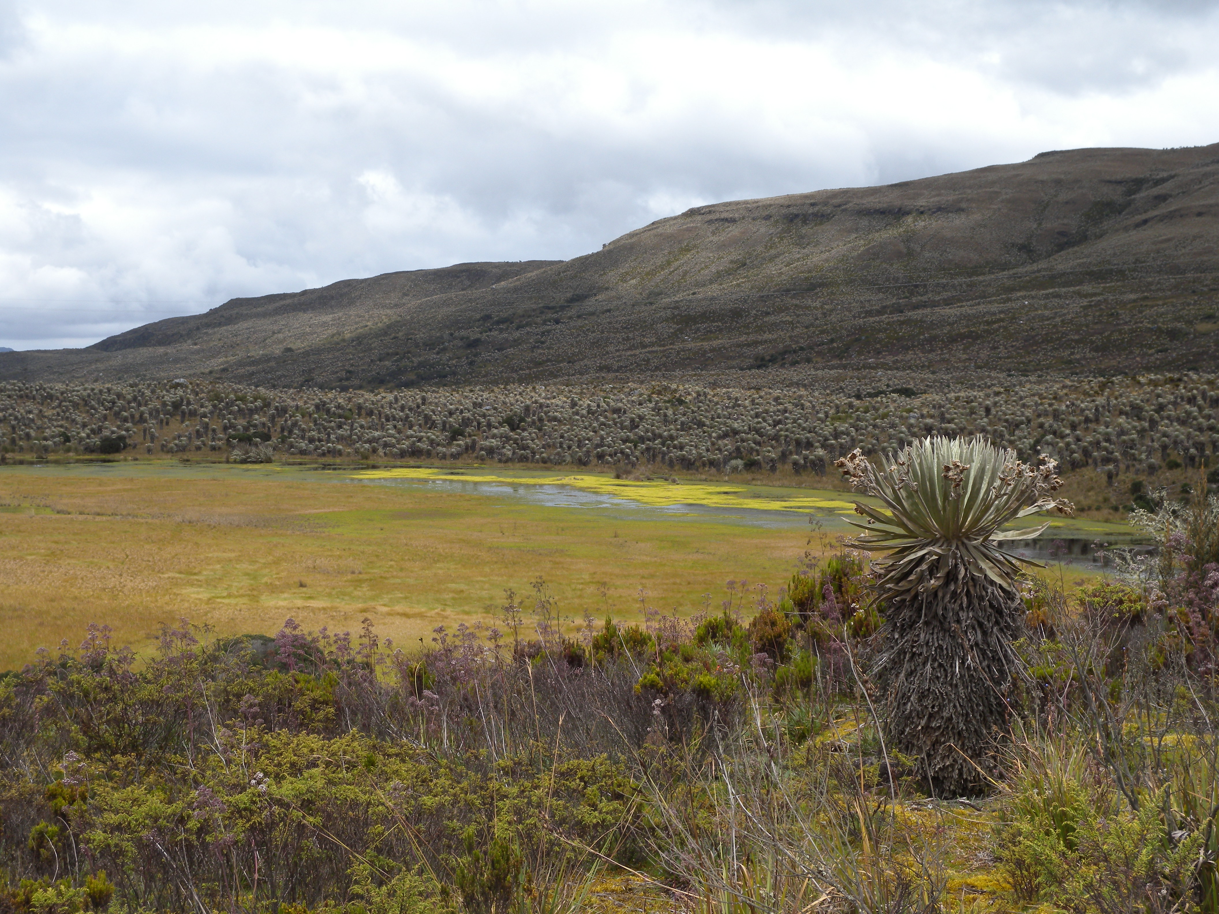
Stefania Gallini, Sumapaz Páramo, 2013
Stefania Gallini, Sumapaz Páramo, 2013
Some of the environmental problems that the Sumapaz Páramo has faced include the eutrophication of lakes and the substitution of native vegetation for crops and pastures.
All rights reserved. 2013. Courtesy of Stefania Gallini.
The copyright holder reserves, or holds for their own use, all the rights provided by copyright law, such as distribution, performance, and creation of derivative works.

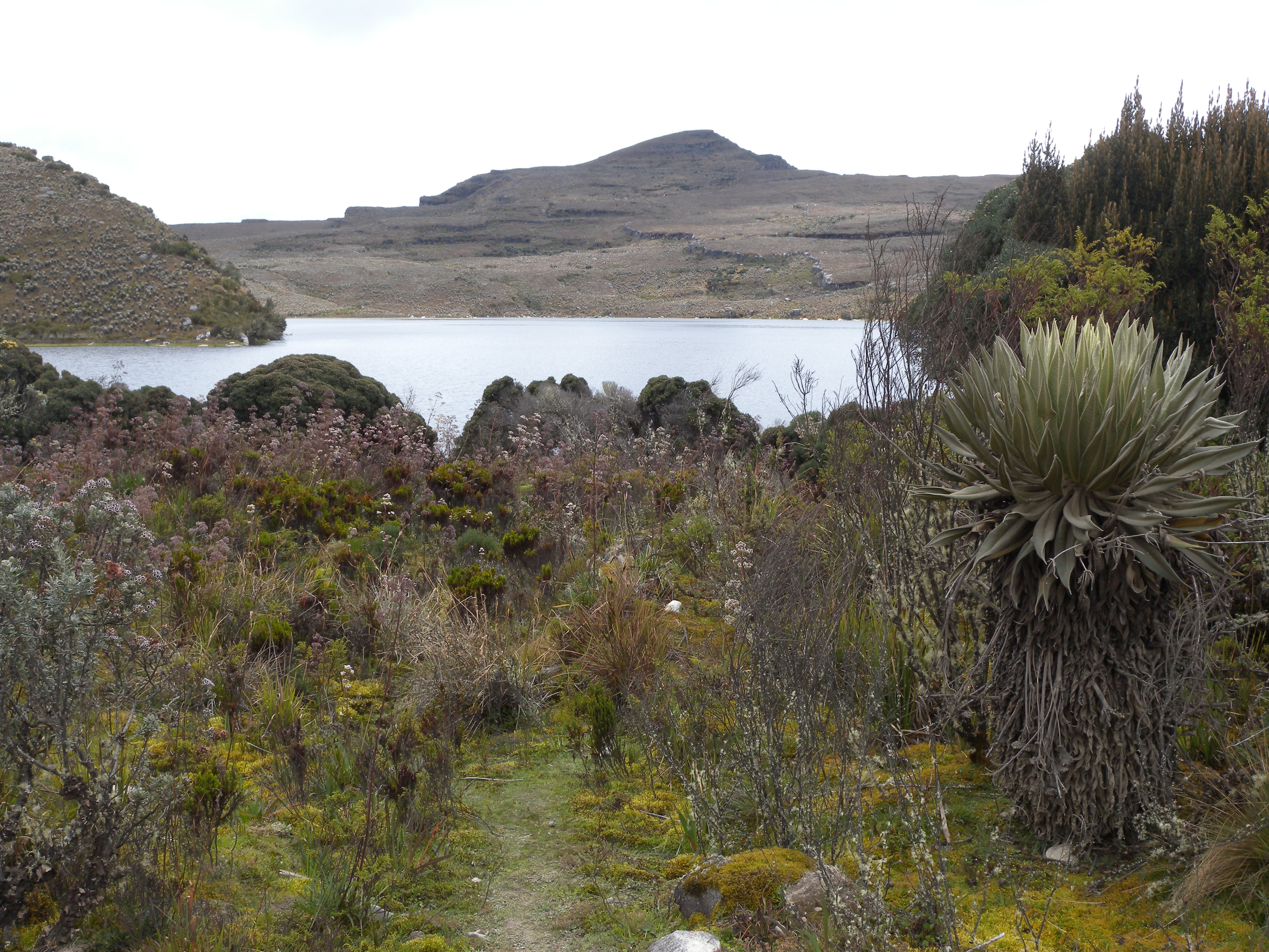
Stefania Gallini, Sumapaz Páramo, 2013
Stefania Gallini, Sumapaz Páramo, 2013
Sumapaz Páramo—the largest páramo in the world—is located in southeast Bogotá. A national park since 1977, it is the source of many tributary rivers of the Magdalena and Orinoco basins. The Tunjuelo River—a tributary of the Bogotá River that in turn empties into the Magdalena River—flows from the Sumapaz Páramo.
All rights reserved. 2013. Courtesy of Stefania Gallini.
The copyright holder reserves, or holds for their own use, all the rights provided by copyright law, such as distribution, performance, and creation of derivative works.
The perimeter of the city in the late nineteenth century did not exceed the area between the Fucha and the Arzobispo Rivers, with the exception of the suburban neighborhoods of San Cristóbal in the south and Chapinero in the north. Most people that settled in these districts sought to escape the unsanitary conditions of the city center, exchanging them for fresh air in the urban fringes and finding relief in the clean waters of the San Cristóbal River and La Vieja and Las Delicias Rivulets. The linear expansion of the city that followed during the early twentieth century was parallel to the eastern mountain chain, but the rise of scattered neighborhoods to the west was evident from the 1920s. Henceforth Bogotá expanded its range to the north, south, and west and even on steep terrain in the Eastern Mountains, crossing over rivers, channeling their riverbeds, and draining wetlands. Nowadays, the city limits reach the Bogotá River to the west, making many neighborhoods more vulnerable to regular river overflows.
Chapters
The four chapters of the exhibition tell different but complementary stories of the historical discourse sketched above. The first two chapters entangle people’s everyday life experiences with water, at a time when the sanitary revolution and urban growth touched the private spheres of individuals and families. Chapter one provides a perspective on the relationship between environment, labor, and gender by focusing on laundry and female laundry workers, while chapter two walks visitors through the consolidation of personal hygiene practices and the roles that sanitary housing, bathrooms, and cosmetic products had in this process.
The third and fourth chapter offer an interpretative glimpse to the more visible, studied, and better-documented features of the making of a modern city. Chapter three addresses the construction of water supply infrastructure in relation to the population growth of the city and according to the parameters of sanitary engineering. An environmental perspective on these long-lasting hot topics of urban and technological history enables disclosure of the importance of a web of ecological relations sustaining a city: its modernity and expansion depended on river basins and the páramos that were increasingly more distant from the city center, and transformed wetlands that once were economically productive and hydrologically vital. The fourth and final chapter introduces the issue of waste and water pollution, revealing a dramatic consequence of such interdependence: the contamination of the Bogotá River.

Laura Felacio, Chingaza National Park, 2013
Laura Felacio, Chingaza National Park, 2013
View of the Laguna de los Patos, one of the glacial lakes located in the Chingaza National Park, which was created in 1977 to promote the conservation of the ecosystem. Today, the Chingaza Páramo remains the main source of water for the city of Bogota.
All rights reserved. 2013. Courtesy of Laura Felacio.
The copyright holder reserves, or holds for their own use, all the rights provided by copyright law, such as distribution, performance, and creation of derivative works.

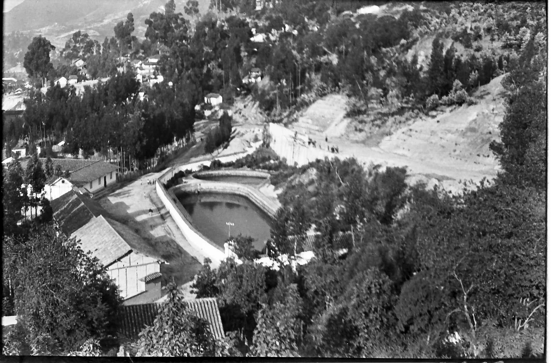
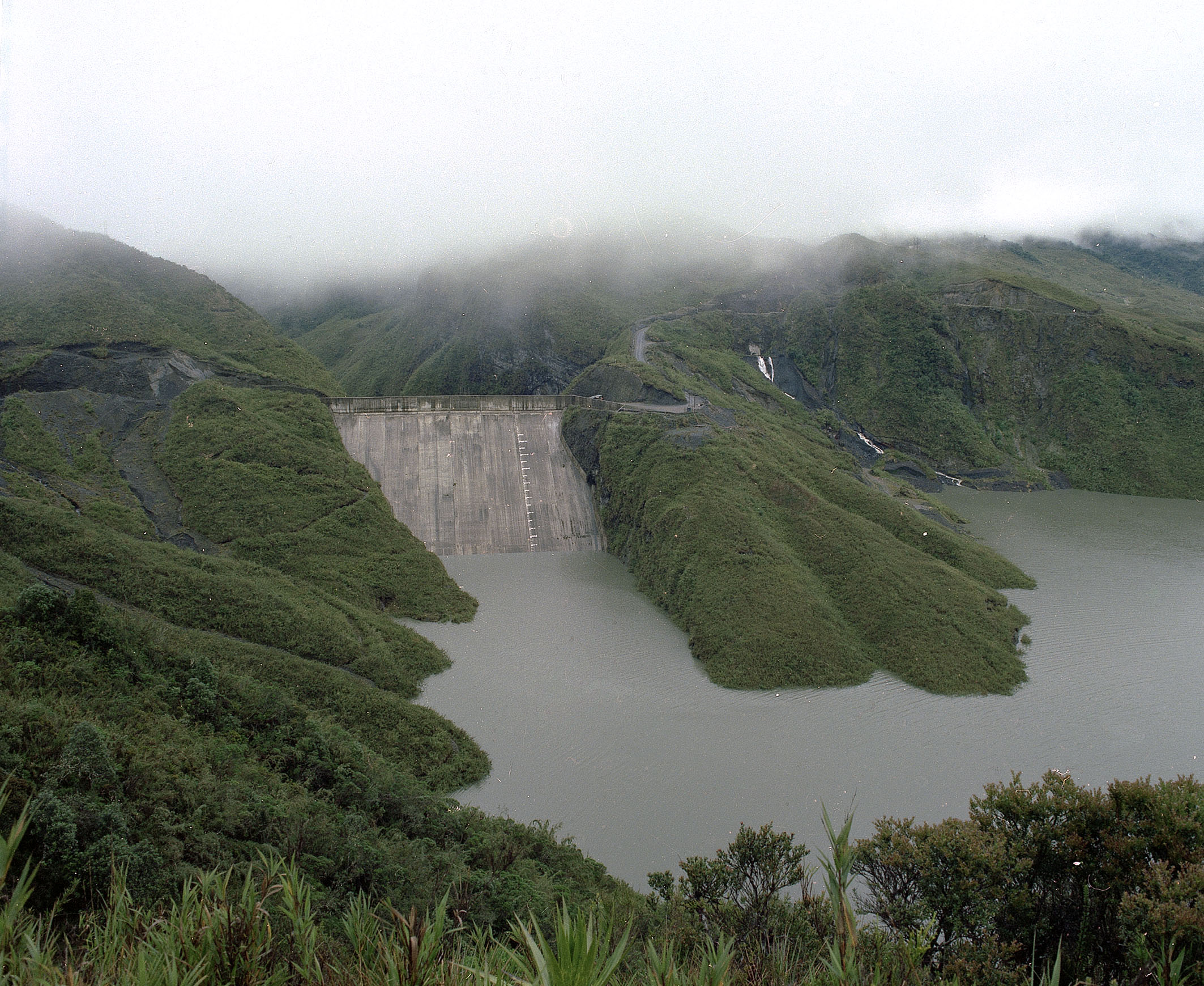
Saúl Ordúz, Proyecto Chingaza, 1982
Saúl Ordúz, Proyecto Chingaza, 1982
The Golillas Dam and Chuza Reservoir, the main works of the Chingaza Páramo project developed between 1972 and 1985. This project was an ambitious technological investment in water supplies for an urban population that would continue to grow throughout the twentieth century. It was also proof of the historical importance of the high and rainy páramos for the sustenance of urban dynamics.
All rights reserved. Courtesy of Museo de Bogotá. Instituto Distrital de Patrimonio Cultural.
The copyright holder reserves, or holds for their own use, all the rights provided by copyright law, such as distribution, performance, and creation of derivative works.
Methods and sources
Although we are fully aware that users of virtual exhibitions are more likely to “see” than read, we do hope that the exhibition will be used as an integrated multimedia experience. This does not mean that the visitor must strictly follow the chapter order: in fact, we love the freedom that digital media facilitates more readily than books. That is why we have constructed each chapter as a separate, although connected, piece of a wider picture.
Considerable effort has been put into uncovering new visual and textual sources on the history of Bogotá from local public libraries, archives, and museums, as well as into presenting them in a creative but academically rigorous way. The result is a collection of articles and print advertisements from newspapers and magazines, municipal regulations, institutional reports, statistical yearbooks, dissertations by physicians and engineers, popular education manuals, and historical fiction novels. Photographs, paintings, drawings, urban maps, and documentary videos also form part of this collection of primary sources.
When enthusiastically embracing this unusual opportunity to set up a virtual history exhibition, we did not anticipate the complexity of gaining copyright permission for each visual source included in the exhibition. Colombian copyright legislation is restrictive, imprecise, and often confusing, and the copyright holders of several visual sources have been difficult to identify.
Coping with the challenge of coordinating a multidisciplinary team of graphic designers, architects, cartographers, musicians, and translators was also complex but enormously stimulating and productive. Thanks to this team, many of the primary sources have been reworked in order to present information that is accessible and pleasing to the eyes and sensibilities of visitors to the virtual exhibition. It therefore includes specifically designed infographics, a timeline with newspaper clippings, dynamic virtual cartography (see the section on historical cartography), original silent videos with background music, and architectural renderings of workers’ housing projected from primary sources.
How to cite
Gallini, Stefania, Laura Felacio, Angélica Agredo, and Stephanie Garcés. “The City’s Currents: A History of Water in 20th-Century Bogotá.” Environment & Society Portal, Virtual Exhibitions 2014, no. 3. Rachel Carson Center for Environment and Society. https://doi.org/10.5282/rcc/6295.
ISSN 2198-7696 Environment & Society Portal, Virtual Exhibitions
 2014 Stefania Gallini, Laura Felacio, Angélica Agredo, and Stephanie Garcés
This refers only to the text and does not include any image rights.
Please click on an image to view its individual rights status.
- Previous chapter
- Next chapter
The City's Currents: A History of Water in 20th-Century Bogotá
This exhibition explores the role of water in the struggle of Colombia’s capital to become a modern city. For Bogotá, complying with the standards of sanitary reformers and the governing elite was a social, technological, and environmental control endeavor. The exhibition examines everyday and gendered experiences of water, such as washing clothes or bathing, as well as urban infrastructural interventions including the domestication of rivers for water supply and wastewater disposal systems.
Stefania Gallini, Laura Felacio, Angélica Agredo, and Stephanie GarcésAbout the author


