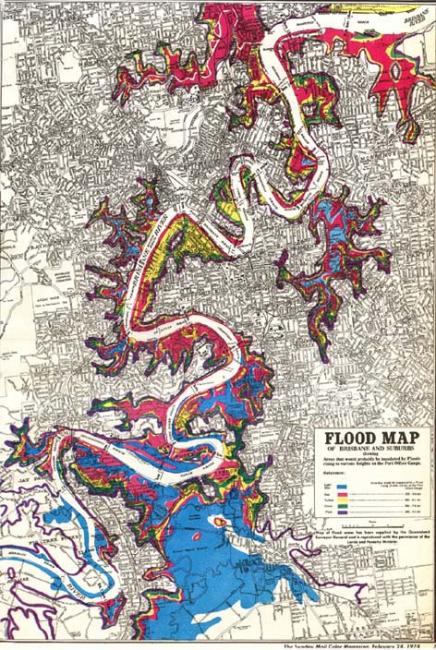
1974 Flood Map
1974 Flood Map
Image courtesy of Brisbane City Council.
 This work is licensed under a Creative Commons Public Domain Mark 1.0 License.
In the La Niña year of 1974, an estimated 900 billion tons of rain fell throughout the state of Queensland in January alone. As Brisbane, Queensland’s capital city, prepared for its annual Australia Day public holiday on 26 January, a large monsoonal trough, associated with Cyclone Wanda, hovered above the 13,500 km² Brisbane River catchment. A slow-moving depression dumped huge amounts of rain, flooding local creeks and the Bremer River tributary upstream in Ipswich. Brisbane experienced three separate intense rain events, with a record 600 mm of rain falling over three days. On 26 January, Brisbane received 314 mm of rain, which was only the second recorded time that the average monthly rainfall was exceeded in 24 hours and made it the city’s wettest day in 87 years. The capital braced itself for riverine floods. On 29 January, the river peaked at 5.45 meters in Brisbane city, the largest floods since 1893 (8.35 m and 8.09 m). The 1974 flood remains Brisbane’s fifth-highest recorded flood.
In 1959, the Government had completed the construction of Somerset Dam, a dual-purpose structure, designed to provide water supply and mitigate floods. Much of the populace believed major floods to be a thing of the past. Consequently, urban and industrial development flourished on the floodplain in Brisbane, significantly increasing the flood hazard. As floodwaters surged towards the city, substantial damage was inevitable.
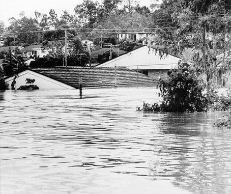
Houses submerged to roof height in the suburbs
Houses submerged to roof height in the suburbs
Photo courtesy of Brisbane City Council.
This work is licensed under a Creative Commons Public Domain Mark 1.0 License.
Rain fell, and spectators watched in awe as the turbulent river raced at 22–25 kilometers per hour towards Moreton Bay. Local newspapers, the Courier Mail and Sunday Mail, offered graphic descriptions: “houses were swept into raging floodwaters,” “ripped off their stumps, steel walls of factories were torn open, and luxury craft were smashed to matchwood.” The river, now more than three kilometers across at its widest, having swelled into its floodplain, submerged or destroyed all in its path. Upstream, land lay inundated to a depth of nine meters, leaving buildings submerged to roof height for up to three days.

Aerial view of Alice and Margaret Streets in central Brisbane
Aerial view of Alice and Margaret Streets in central Brisbane
Photo courtesy of Brisbane City Council.
This work is licensed under a Creative Commons Public Domain Mark 1.0 License.
Floodwaters cut highways and railway lines and closed the airport to jets. Only one bridge over the river remained open, streets became canals, and Brisbane became largely isolated. Flooded suburbs were left without gas, and electricity supplies were thwarted with suburban substations and the main power station inundated. Coal production, 40 kilometers upstream in Ipswich, ceased, with stored supplies left rain soaked. Raw sewage from the submerged Ipswich sewerage plant and domestic outhouses poured into the river. Debris, chemical contaminants, dead fowl, horses, and cattle floated in the floodwaters, increasing the risks of gastroenteritis and tetanus. As the flood waters receded, they left behind layers of disease-carrying sludge, and the rancid smell of mud and effluent permeated the air.

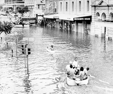
Edward Street in the city
Edward Street in the city
Photo courtesy of Brisbane City Council.
This work is licensed under a Creative Commons Public Domain Mark 1.0 License.
The floods claimed 14 lives in Brisbane and affected 13,000 homes in 30 suburbs—left submerged, inundated, or damaged. These figures are substantial in a city of 712,500 people with 217,847 dwellings. People wept openly in the streets as they returned to the shells of their homes, their possessions destroyed, or reduced to rubble. With agricultural areas destroyed and food left rotting in the Brisbane Markets, the community faced food shortages. Many industries, shops, and businesses struggled to resume work, threatening the livelihood of the businesses and their employees alike. The estimated damage stood at a crippling AU$178 million. Parliamentarian Bill Lickiss pronounced the event a “flood disaster that is unparalleled in the history of this State.”
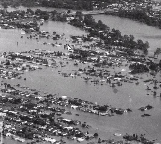
Aerial view of suburb of Chelmer where streets disappeared and houses were submerged
Aerial view of suburb of Chelmer where streets disappeared and houses were submerged
Photo courtesy of Brisbane City Council.
This work is licensed under a Creative Commons Public Domain Mark 1.0 License.
The floods should have once again brought into question the wisdom of building on a floodplain, providing a chance to modify human behavior. The parliamentary opposition and the community called for a public inquiry to investigate the extensive damage and avoid a repetition of such devastating flooding. But Queensland’s Conservative government refused, committing instead to the construction of a second flood-mitigation and water-supply dam, Wivenhoe. The over-reliance on structural engineering, rather than floodplain management to reduce the hazard, continued.
How to cite
Cook, Margaret. “The Australia Day Floods, January 1974.” Environment & Society Portal, Arcadia (Spring 2017), no. 15. Rachel Carson Center for Environment and Society. https://doi.org/10.5282/rcc/7871.
ISSN 2199-3408
Environment & Society Portal, Arcadia
 This work is licensed under a Creative Commons Attribution 4.0 International License.
2017 Margaret Cook
This refers only to the text and does not include any image rights.
Please click on an image to view its individual rights status
- Bankoff, Greg, George Frerks, and Dorothea Hilhorst. Mapping Vulnerability: Disasters, Development, and People. London: Earthscan, 2004.
- Cook, Margaret. “Damming the ‘Flood Evil’ on the Brisbane River.” History Australia 13, no. 4 (2016): 540–556.
- Department of Science Bureau of Meteorology. Brisbane Floods January 1974. Canberra: Australian Government Publishing Service, 1974.
- Department of Social Security. Queensland Flood Report Australia Day 1974. Canberra: Commonwealth of Australia, 1981.
- Mauch, Christof, and Christian Pfister, eds. Natural Disasters, Cultural Responses: Case Studies toward a Global Environmental History. Lanham: Lexington Books, 2009.
- O'Gorman, Emily. Flood Country: An Environmental History of the Murray-Darling Basin. Melbourne: CSIRO Publishing, 2012.


