The current borders of the Serengeti National Park stem from 1959. They represent an attempt to accommodate within the strictly protected park most of the migratory routes of the Serengeti ungulates. Migratory routes, in the Serengeti and elsewhere, have been known to be unstable, however. Migration is affected by changes in population numbers, and the size of Serengeti ungulate populations has varied greatly in the past. Long-term evaluations of ungulate populations and the movement of migrating herds are thus regarded as essential to devising effective conservation strategies.

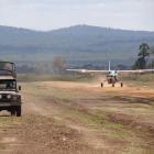
A Cessna landing alongside a Land Rover in Mikumi National Park, Tanzania. Light airplanes and the view from above still play an important role in migration research and conservation in national parks.
A Cessna landing alongside a Land Rover in Mikumi National Park, Tanzania. Light airplanes and the view from above still play an important role in migration research and conservation in national parks.
Photograph by Adam Jones, 2013.
Accessed via Wikimedia on 5 November 2020. Click here to view source.
 This work is licensed under a Creative Commons Attribution-ShareAlike 2.0 Generic License.
Since the late 1950s, observation from the air has played an important role in monitoring migration and in colonial endeavors to keep in check local human populations seen as a threat to the park’s wildlife. Real-time aerial monitoring was deeply rooted in colonial networks of European presence in African parks. The use of aerial technologies itself was a means to strengthen white monopolies of conservation knowledge. At the same time, aerial technologies, imported from the centers of international conservation in Europe or the United States, bolstered the influence of international, scientific organizations on local, colonial game authorities in the periphery. Nevertheless, during the 1950s and 1960s, the introduction of light airplanes, such as Cessnas and Piper Super Cubs, into zoological fieldwork led to new forms of cooperation between colonial game wardens and visiting researchers that dominated wildlife research and management until the introduction of cheaper cameras and, later, remote sensing by satellite in the 1970s, 1980s, and 1990s.
Aerial observation emerged at the beginning of the twentieth century in a military context. By 1960, aerial observation had become important in ecological research concerned with the interaction between species and with animals and their environment. Light propeller planes with two-passenger cabins, able to take off and land on short runways, made possible the study of fast-moving mammals in territories difficult to access by car and too vast to traverse on foot.
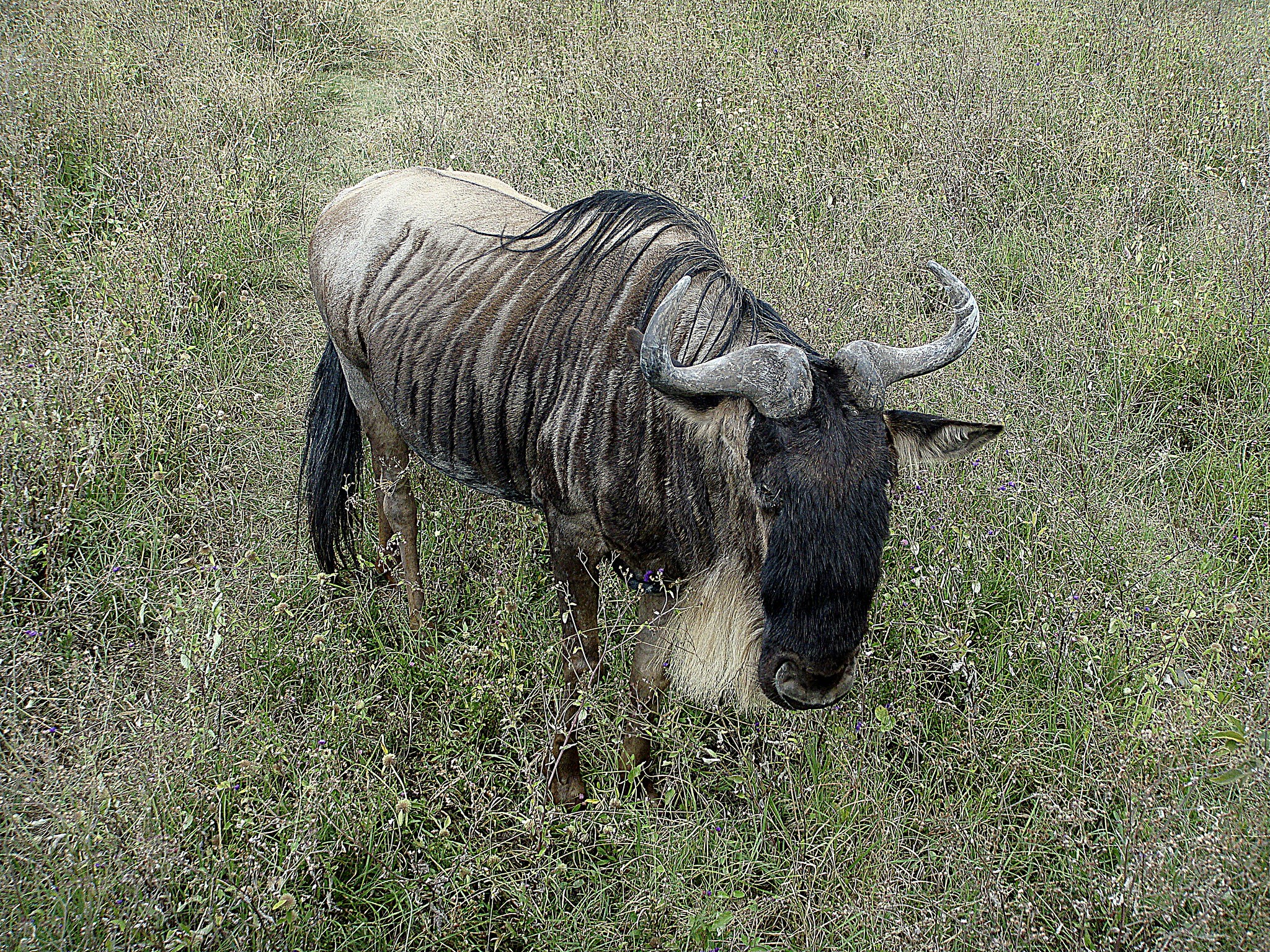
Among the Serengeti’s four seasonally migrating species, aerial observations focused predominantly on the wildebeest. The wildebeest lent itself well to aerial surveys, as each animal had a distinctive light patch on its back, which facilitated the recognition of individual animals. Wildebeest migration, in this way, not only stood in for the behavior of other ungulate species in the Serengeti, but also determined spatial management strategies for the Serengeti National Park and its surrounding areas.

Wildebeest in the Ngorongoro Crater, Ngorongoro Conservation Area, Tanzania. The wildebeest lent itself well to aerial surveys as each animal had a distinctive light patch on its back, which facilitated the observation of individual animals.
Wildebeest in the Ngorongoro Crater, Ngorongoro Conservation Area, Tanzania. The wildebeest lent itself well to aerial surveys as each animal had a distinctive light patch on its back, which facilitated the observation of individual animals.
Photograph by amanderson2.
Accessed via Flickr on 5 November 2020.
 This work is licensed under a Creative Commons Attribution 2.0 Generic License.
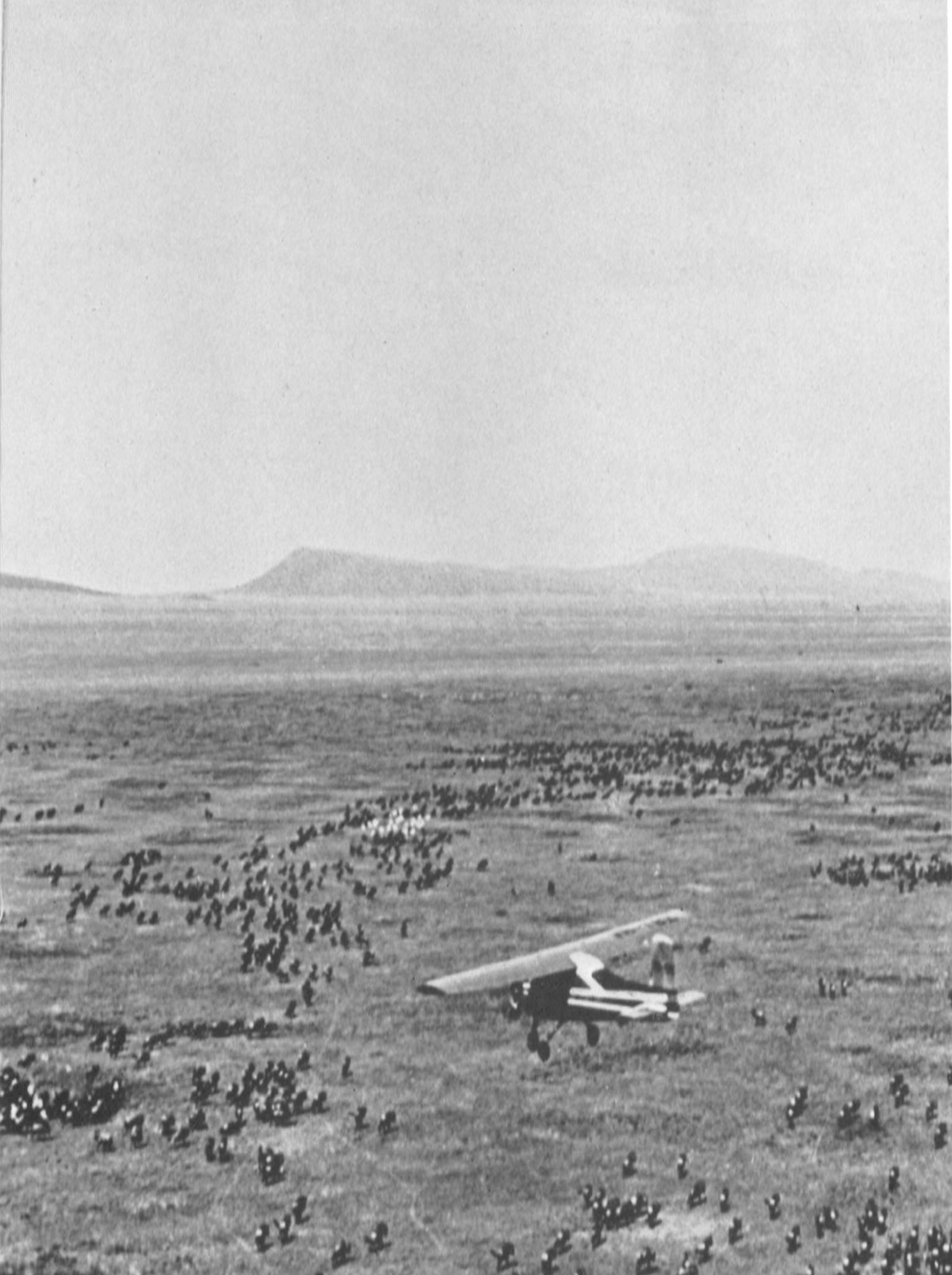
Two advocates of aerial observation were Murray Watson, a doctoral candidate at Cambridge University in the mid-1960s, and Myles Turner, chief game warden of the Tanzanian National Parks (TANAPA). For his dissertation, Watson devised a survey method for wildebeest censuses. Assisted by Turner, Watson used a Cessna 150 to conduct aerial counts of sample strips, covering up to 20 percent of the surveyed terrain. Watson preferred direct counting from the airplane, as this allowed him to take into consideration wildebeest movements through different types of ground situations, for instance when migrating herds mingled with resident herds of wildebeests or with herded cattle. Only in cases of very large herds were photographs taken to facilitate the counting. Using small airplanes allowed for the detailed and continuous plotting of the routes of migrants. This movement was placed into new causal contexts, observing the environments through which wildebeests moved at different times of the year, including the types of vegetation they fed on.
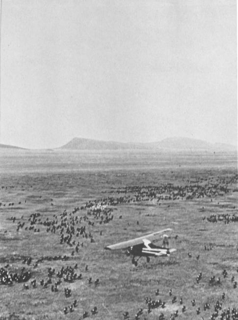
“Counting Wildebeest in the Serengeti”. Photo taken during Turner’s and Watson’s survey of Serengeti wildebeests in 1963.
“Counting Wildebeest in the Serengeti”. Photo taken during Turner’s and Watson’s survey of Serengeti wildebeests in 1963.
Unknown photographer, 1963.
© Cambridge University Press
Originally published in Turner, M. I.M., and R. M. Watson. “Game Management and Research by Aeroplane.” Oryx 8, no. 1 (1965): 13–22. https://doi.org/10.1017/S0030605300003744.
Used by permission
The copyright holder reserves, or holds for their own use, all the rights provided by copyright law, such as distribution, performance, and creation of derivative works.
Although often skeptical towards incoming, short-term researchers, game wardens such as Turner, too, adopted aerial mobilities. The local realities of both research and park management demanded displacements over vast distances. The view from the “all-seeing aeroplane,” as described by Turner and Watson in a publication from 1965, allowed game wardens like Turner to monitor predation and poaching, which threatened herds of wildebeests on the move and, occasionally, to recover lost tourists.
Aerial observations sustained not only forms of cooperative field work but also a particular perception of human-wildlife interaction, which differed from the strictly preservationist regime of park management of the 1940s. Real-time aerial observation could support mixed forms of land use, including conservation, land cultivation, and to a limited degree hunting of game. By observing wildebeest routes, game wardens could encourage the grazing of domesticated cattle in areas outside of the annual migratory corridors, and, in game control areas such as Loliondo, northwest of the national park, ensure that hunting did not surpass the 10 percent of migratory wildlife which, at the time, was considered unproblematic. Often these assumptions were falsely based on idealized ideas about a natural harmony between local pastoralists and wildlife. Yet, management based on aerial observation tolerated—at least to some extent—human activities such as pastoralism, agricultural cultivation, and hunting, where these did not disturb the annual migration patterns of wildebeests in the park and its direct surroundings.
The tight cooperation between white wardens and visiting researchers brought about by the introduction of light airplanes into ecological fieldwork lasted only for a short while. Real-time observation lost its dominance in the course of the 1970s when the decolonization of the TANAPA and the introduction of improved photographic and, later, computer monitoring technology replaced old networks and required new forms of expertise. Aerial photography, and later satellite tracking, continued to support colonial politics of knowledge production, while leaving less room for experimentation with forms of land use than did live observations. Views from above, by airplanes, satellites, and drones, still dominate migration research and conservation work in national parks. Their inbuilt politics deserve more attention.
How to cite
Schleper, Simone. “Views from Above: Light Airplanes and Wildlife Research and Management in the Serengeti during the 1950s and 1960s.” Environment & Society Portal, Arcadia (Autumn 2020), no. 42. Rachel Carson Center for Environment and Society. https://doi.org/10.5282/rcc/9153.
ISSN 2199-3408
Environment & Society Portal, Arcadia
 This work is licensed under a Creative Commons Attribution 4.0 International License.
2020 Simone Schleper
This refers only to the text and does not include any image rights.
Please click on the images to view their individual rights status.
- Benson, Etienne. Wired Wilderness: Technologies of Tracking and the Making of Modern Wildlife. Baltimore: Johns Hopkins University Press, 2010.
- Gissibl, Bernhard, Sabine H. Höhler, and Patrick Kupper. Civilizing Nature: National Parks in Global Historical Perspective. New York: Berghahn Books, 2012.
- Lekan, Thomas. Our Gigantic Zoo: A German Quest to Save the Serengeti. Oxford & New York: Oxford University Press, 2020.
- Neumann, Roderick P. “The Postwar Conservation Boom in British Colonial Africa.” Environmental History 7, no. 1 (2002): 22–47.
- Talbot, Lee M., and Martha H. Talbot. “The Wildebeest in Western Masailand, East Africa.” Wildlife Monographs 12 (September 1963): 3–88.
- Turner, Myles, and R. Murray Watson. “Game Management and Research by Aeroplane.” Oryx 8, no. 1 (1965): 13–22. doi:10.1017/S0030605300003744.
- St. Joseph, John K.S., ed. The Uses of Air Photography. 2nd ed. London: John Baker, 1977.


.jpg)