Multimedia | image
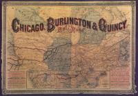
Map: CB&Q map of Chicago, 1880
This 1880 map centered on Chicago displays the early CB&Q railroad route.
This 1880 map centered on Chicago displays the early CB&Q railroad route.
The authors explore the implementation of Traditional Ecological Knowledge (TEK) and Indigenous knowledge (IK) in mapping efforts, taking cues from previous spatio-temporal visualization work in the Geographic(al) Information System(s)/Science(s) GIS community, and from temporal depictions extant in existing cultural traditions.