
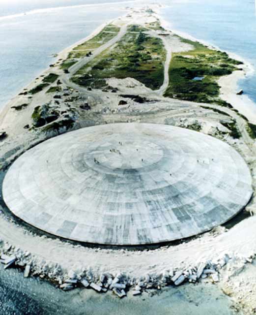
Dome on Runit Island, Enewetak Atoll, Marshall Islands, covering a crater created by a US nuclear weapons test in 1977. The crater and dome now contain 84,000 cubic meters of radioactive soil from other islands in the Enewetak Atoll. Unknown photographer.
Dome on Runit Island, Enewetak Atoll, Marshall Islands, covering a crater created by a US nuclear weapons test in 1977. The crater and dome now contain 84,000 cubic meters of radioactive soil from other islands in the Enewetak Atoll. Unknown photographer.
Public Domain. Courtesy of US Defense Special Weapons Agency.
 This work is licensed under a Creative Commons Public Domain Mark 1.0 License.
This image appears in: Hsu, Hsuan. “Representing Environmental Risk in the Landscapes of US Militarization.” Environment & Society Portal, Virtual Exhibitions 2014, no. 1. Rachel Carson Center for Environment and Society. http://www.environmentandsociety.org/node/6058.
One difficulty faced by environmental justice activists is that the mass media tend to focus on spectacular, catastrophic events rather than on the quiet, unspectacular, and frequently indefinite nature of environmental health risks that unfold gradually over the course of years or generations (Nixon 2011). Media coverage of war, for example, highlights battlefield casualties but rarely details the casualties incurred in the environmental aftermath of such conflicts: as Rob Nixon explains, “each war generates a distinctive, historically specific chemical, radiological, epidemiological, and environmental legacy” (2011, 209). By pioneering the use of new and ethically questionable war technologies such as atomic bombs, Agent Orange, and depleted uranium weapons, the US has produced lethal landscapes and premature deaths that have been quickly forgotten by the American public, if they are even noticed at all.
—Hsuan Hsu
Read more here.
- Alexis-Martin, Becky. “‘It was a Blast!’—Camp Life on Christmas Island, 1956–1958.” Environment & Society Portal, Arcadia (Autumn 2016), no. 19. Rachel Carson Center for Environment and Society. https://doi.org/10.5282/rcc/7693.